General Information and how to get here.
About Honduras
Honduras, located in Central America, is the most mountainous country in the region and the second largest. It shares borders with Guatemala, El Salvador and Nicaragua.
Capital : Tegucigalpa (TGU)
Currency : Lempira (L)
Language : Spanish
Highest point : Celaque 2,849 m / 9,347.1 ft
Major Religion : Catholic majority
PARAGLIDING ACTIVITIES
Our main flying site is located 75km away from Tegucigalpa in the town of Villa de San Francisco, Francisco Morazan, a 1.5 hr drive from the city. We fly year-round when the weather cooperates, but prime paragliding season begins from February to May, where the best thermal flying happens. You can expect very strong days, it is recommended to have experience in thermal and mountain flying. Please get in contact with the local community and association when planning your visit.
Location : https://maps.app.goo.gl/NxeVA1dq88ENXqvP6
HOW TO GET HERE
Airports
You can arrive via direct flights to our 2 main international airports:
| Airport | City | Distance to TGU | Distance to Flying Site |
|---|---|---|---|
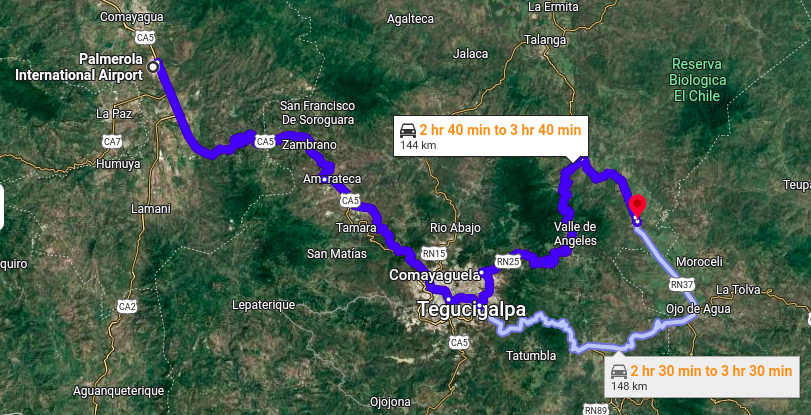
| XPL | Comayagua | 1.5 hour | 3 hours |
| SAP | San Pedro Sula | 3.5 hour | 5 hours |
Both international airports have direct flights with the USA and Mexico, so you can plan your flying season with this in mind.
If you arrive to SAP consider connecting with a domestic flight and arrive to TGU and make your trip shorter.
Bus and Taxi services at available at the airport. You can ask for details at the information kiosk near the airport exit.
Arriving by land to Honduras
Honduras has land borders with Guatemala, El Salvador and Nicaragua.
The two main bus companies are Pullmantur and TicaBus. Both connect with Tegucigalpa.
From Tegucigalpa to our flying site
You can arrive to Villa de San Francisco by rural bus or taxi. There are two lines, cost per person up to 5$.
Bus Stations
| Station | Location Link | Coordinates |
|---|---|---|
| Jacaleapa Station | https://maps.app.goo.gl/DpfzYHJhxyqv15s8A | 14°04'09.3"N 87°11'02.6"W |
| Guanacaste Station | https://maps.app.goo.gl/QzYKRgm1Ziy1G1Rn6 | 14°06'21.6"N 87°11'52.8"W |
WHERE TO STAY
This will depend on your tastes and preferences. Our flying site is located in the mountains between the towns of Villa de San Francisco and Valle de Ángeles.
Villa de San Francisco is a small, developing town with limited options, so don't expect luxury or many amenities. However, it is located just a short walk from our landing zone.
Valle de Ángeles is a tourist town with many options for hotels, Airbnbs, and cabins. It also has a wider variety of restaurants and better infrastructure. 30 km away from Villa de San Francisco.
If after your flight you are looking for something more luxurious and comfortable, with plenty of dining options, then we recommend Valle de Ángeles.
But if what you are looking for upon landing is to get to your hotel as quickly as possible, we recommend Villa de San Francisco.
If you end up staying in Valle de Angeles, you should look into arranging transportation early, taxis are available for hire. Direct bus transportation is available every 4hrs between Villa de San Francisco and Valle de Angeles, or you can connect bus lines every hour from Valle de Angeles to Cantarranas and Cantarranas to Villa de San Francisco.
PS: If you like Hike and Fly, then staying in Valle de Angeles is a good option. Our site is located 10km away walking through the forest.
Need help with something?
We hope this information helps you plan your trip, but if you have any specific questions or need help, please don't hesitate to contact us.